All posts by Other Paul

Toyota BJ60 big red stuck in snow

Sunday Stroll In The “Tillamook” Park

Toyota BJ60 airing downWe took a light Sunday stroll through parts of the Tillamook State Forest, west of Portland. Joining me in Big Red (a 3B-powered BJ60) on this rainy President’s Day eve, is Chris “Young Turk” Pesek. The outing is long overdue; over the past year, we probably haven’t wheeled three times between us. (Let us pause for the compulsory moment of mourning and handwringing.) If that wasn’t bad enough, Old Man LGRT has been on our backs, threatening to strip our LGRT team status if we didn’t address our Nature Deficit Disorder “with all due haste”. YT (naturally) is in better shape than me, getting some time in on his dual-sport cycle. And his cycling buddy Eric is along for the ride in Big Red. (Eric has the wheeling bug now as well, and is furiously in search of his first wheeling rig. Feel free to post your vehicle suggestions to LGRT.)

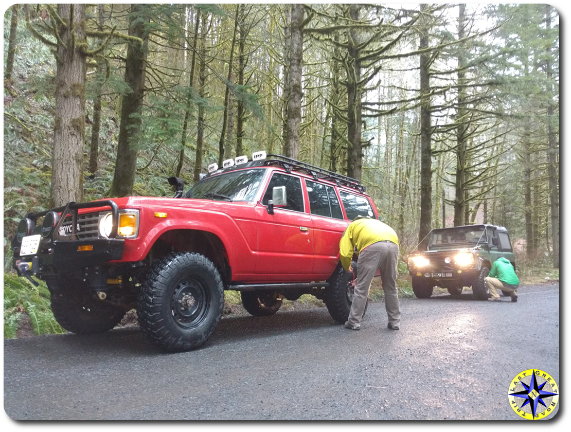
After picking up ATV permits at the Shell station along Highway 6 (near milepost 42), and a few whacks on Big Red to free up a recalcitrant parking brake, we fly straight past Rogers Camp trailhead on the way to South Fork Road (just past milepost 28, on the left). We’d planned to do a route we’d done many times before: head up South Fork Road (through Lyda camp) to the Hoodraiser and nearby Hogs Back trails, follow C-Line Road southeast near the south boundary of the park to Firebreak Five, and then run Cedar Tree top to bottom (and north) on the way out to Rogers Camp and Highway 6.

deford hoodraiser trail
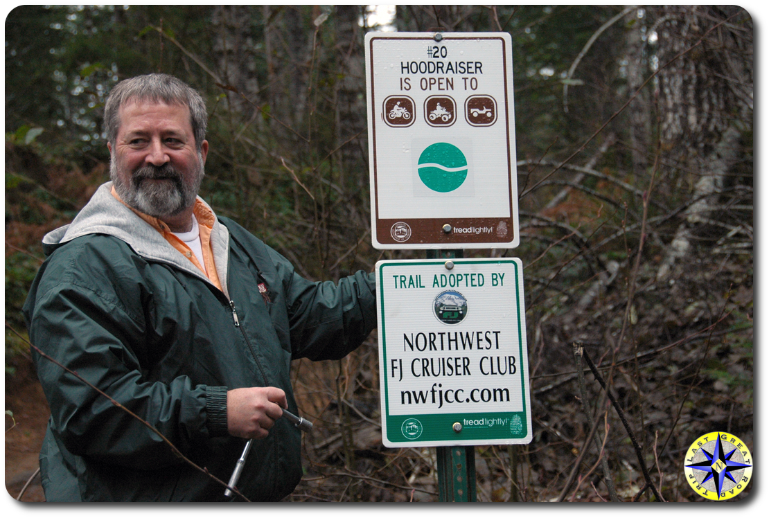
Hoodraiser is a nostalgic favorite. Chris and I cut our wheeling teeth with the Northwest FJ Cruiser Club, which had adopted Hoodraiser when we were members. (And had FJ Cruisers. The FJ Cruiser has proven itself a notoriously effective gateway drug. Eric, take note.) With our friends in the NWFJCC, we’d spent many many happy hours maintaining the trail.

Hoodraiser is an easy drive with few turns, traversing up and over many swail berms, hence the trail’s name. On the second half of this warm-up trail, the snow depth steadily increases as we climb, until at last there are no recent tracks. On one of the last climbs, Big Red scoots up nicely, but I lose momentum and come to an inopportune stop midway in the climb. The loose, wet snow on top gives way to ice on a couple of quick tries to right matters. It’s early in the day, and the path of least resistance is to back down, turn around, and carry on.Young Turk radio

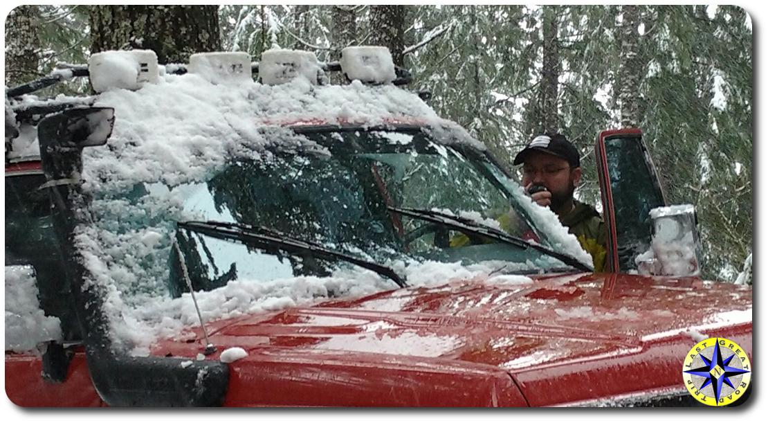
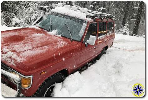
Carrying on (according to plan) involves following South Fork Road uphill, parallel with Hoodraiser. With (now) expected results. We are prepared for this, but after a good stretch of additional rain and warmer temperatures, none of us really expected the amount of snow remaining. (NOAA weather reporting on local snow levels was also off; it would be snowing down to about 1500′ all day, whereas the reported snow level had been 2500-3000′.) On reaching the intersection of South Fork and C-Line (Hoodraiser exits at the top on C-Line), we’re in axle deep, or deeper, snow.

Over the years, Chris has displayed an impressive ability to throw his vehicles into snow with innocent abandon. And true to form, Big Red is soon — wait for it — stuck. A quick pull later, we proceed to saw and crawl the rigs to a nearby bare spot under some some tree cover.BJ60 strapped up for recovery

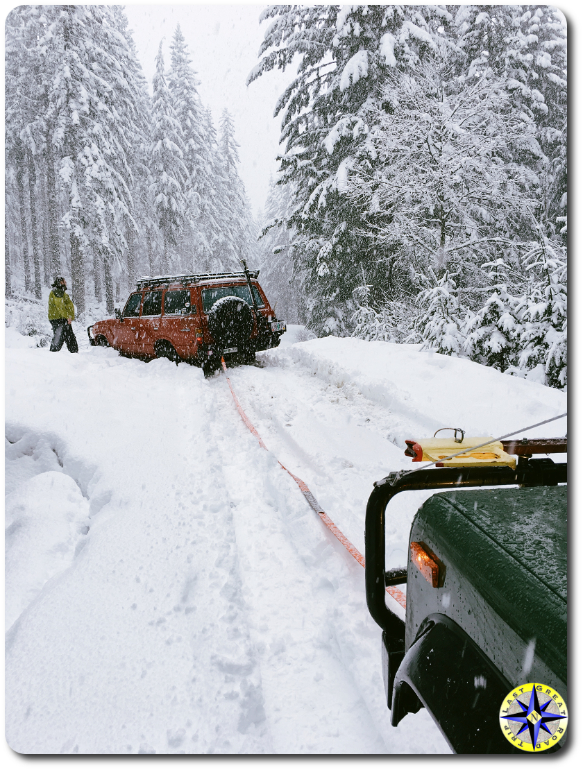
Decision time take two. Air and chain up for the several miles drive along C-Line to get to our chosen next destination (Firebreak Five or Cedar Tree)? Or head back down South Fork to Highway 6 and head to the trails from Rogers Camp? Once again, we opt in favor of an earlier arrival at the (next) trails and limp back east on Highway 6 to the Rogers Camp exit.

The forest has been eerily quiet this Sunday. So far we’ve seen just a trio motorcycles in and around Hoodraiser; we’ll see just a couple trucks along Cedar Tree, running in the opposite direction. The number of trailers parked at Rogers Camp trail head also seems surprisingly light for this holiday weekend.

Our attempt to reach our destination from the east is rewarded. Though the snow gets deeper as we climb, we’re easily able to get to Saddle Mountain Road and to the top of Cedar Tree. Trail ho!

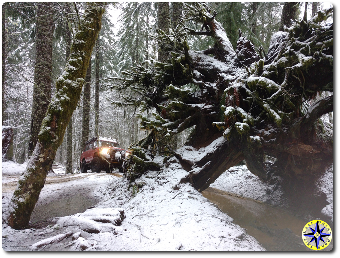
Turning in, we can see some recent tracks through the top of the trail. But Cedar Tree — named for the signature fallen cedar on a lower section under which many (but by no means all) rigs can pass — has a pretty dense canopy, so there’s not a ton of snow on it in any case. This is simply a great Pacific Northwest trail, twisting and turning up and down through the trees and vegetation. There’s not a lot of tricky stuff here, just enough to keep you sharp and provide opportunities for dusting cobwebs off basic skills such as seeing the trail over the hood, good tire placement (and general line picking), and left-foot braking. All in all, this is one delightful drive through the forest.D90 lining up

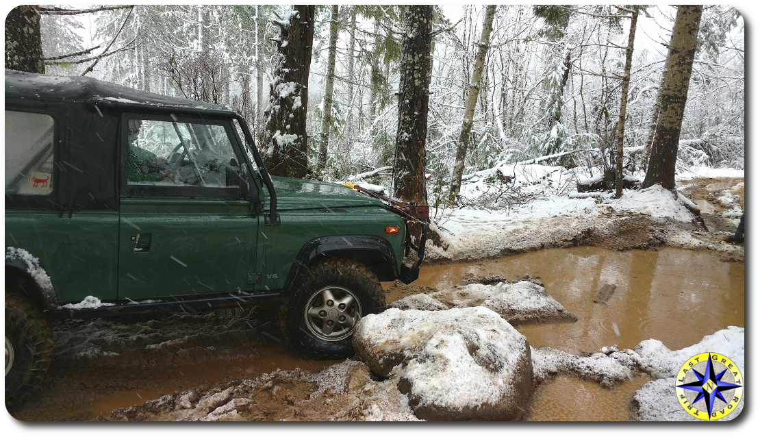
The biggest challenge today comes along a bottom section, with a tight squeeze between some rocks and an inopportunely-placed tree. You know the sort of thing: impending carnage from a downhill-side tree pushes you towards the rocks, while crawling the rocks on the uphill side tips the truck and its external bits into the tree. Rock. Hard place.

Through use, perhaps helped along by the recent spate of wet weather, these particular rocks have become much more dug out — certainly more than we can recall in about ten years of running Cedar Tree. So much so that some very recent, “creative” attempts to avoid the obstacle have widened the trail by cutting an undesignated bypass on the uphill side. It’s hard to know whether to attribute this to ignorance or disregard. But the governing principle here is pretty clear: if you’re unable or unwilling to stay on the trail through an obstacle, carefully turn back. Put another way, if there’s no designated bypass, don’t make one. Far from an exercise in ego-boosting, this is a simple matter of protecting trails so that we all can continue to enjoy them. Tread Lightly out there, kids!

BJ60 approaching the treeSizing things up, we make it over the obstacle relatively unscathed — the stock rear bumper assembly on a NAS Defender 90 enjoys asserting itself — with some light spotting and complete this delightful trail. By now it’s about 3:00PM and I have a good several hours ahead of me to make it back home north of Seattle. And so it’s back to the trailhead to air up, check things out, and head out. Any day wheeling….

Bonus travel-brochure notes

If you don’t already know, the OHV areas in Tillamook State Forest comprise a most excellent off-road trail system, with (according to the 2014 guide and map) more than 250 miles of OHV trails at all skill levels, for everything from motorcycles through four-wheel drive buggies. Managed by the Oregon Department of Forestry (ODF), TSF OHV areas also include multiple campgrounds and trailheads to help make the stay even more enjoyable. As with OHV areas elsewhere in Oregon, the ODF actively partners with clubs and other volunteers for trail maintenance and more should you and/or your club want to become involved as stewards of this considerable resource.

See the links below for additional details:

In addition to being a multiple-use facility, TSF is also a working forest. So while roads and trails are generally well marked, junctions might come and go.

Pictures by Young Turk and Other Paul and Eric Hedaa

Last Great Road Trip window decal

A Utah Backcountry Discovery Route Photo Retrospective

storm clouds over endless highway utah

Shortly following a rain storm, somewhere east of Le Grande, Oregon.

Back in July 2012, I (Other Paul) took a ten-day off-road adventure through the Utah Backcountry Discovery Route (UTBDR) with my friend Paul (LGRT) and (then) new friend Brad.  (Paul and Brad had gone to college together and yet somehow remained friends. This is perhaps more surprising given that the two had shared a vehicle the previous year retracing the route of a recent Baja 1000.  Another of their collegiate friends, it turns out, is married to a woman who, at the time of the UTBDR off-road adventure, was my manager at work, which made for some interesting conversations in the office — and on the trail.  But I digress. Paul and Brad later rejoined forces in 2013 for the 25th-annual TLCA Rubithon on California’s famed Rubicon Trail. Against many odds — or perhaps because of them — they remain friends.)

Paul was driving his well-equipped, smurf-blue FJ Cruiser (a.k.a. the Blue Bunny), with Brad doing his herculean best as navigator to keep Paul on route. (By ‘well-equipped’ I mean that in addition to the usual camping, recovery and field repair kit, Paul’s rig was stuffed to the gills with video, photo and computer gear, leaving Brad the space nearly the size of a small shaving kit in which to stow his things.) For myself, I spent the better part of two weeks sucking FJ Cruiser dust in an old 1995 Rover Defender 90, with an occasional intermission courtesy of the rain or sleet or hail that found its way under the 90’s surrey top.

The trip itself is extensively chronicled through the Utah Backcountry Discovery Route off-road adventure.  One of my assignments on the off-road adventure was determining where to make camp each night. This was a job at which I fared poorly. Fortunately, there was plenty of dispersed camping along the nearly 900-mile route, which we ran “backwards”, north to south, departing from Bear Lake at the Idaho/Utah border. I had set another goal for myself, however: to make friends with a new camera, the wonderful (and sometimes maddening) fixed-lens Fuji x100. Some of the results of those halting first efforts appear below. No doubt I would do many things differently now, but shooting with the x100 isn’t one of them. And although I’ve recently sold it, the x100 (now in its third iteration) is perhaps my favorite digital camera.

sunlight through storm clouds utah

The promise of good weather to come.

pop-n-pins bowling alley building

My route to Bear Lake to meetup with Paul and Brad went through Preston, ID, in which the film Napolean Dynamite was both set and filmed. Preston is home to the Cuttin Curral (Napolean: “I already get my hair cut at the Cuttin Curral”) and the Pop’n Pins Lanes.

gas can fj cruiser roof rack

Fueling up in Bear Lake. Somehow distracted, I left the fill cap to the D90 on top of a pump, which I didn’t discover until after we finished the first leg. Fortunately, the Rover part for the NAS 90 is a rebranded Stant cap, which made replacement a snap.

UTBDR gravel road toyota fj cruiser

No winter maintenance. Just into Utah on the north end of the UTBDR.

Storm clouds over utah mountain rest stop parkin lot

An empty parking lot at a turnout overlooking Kletting Peak along Utah State Highway 150 (near Hayden Pass).

utah canyons fj cruiser land rover defender 90

Strawberry Road forever. Near Strawberry Pinnacles, Duchesne County, Utah.

utah forest meadow

Reservation Ridge was littered with burn piles of (presumably diseased) trees.

mountain aspin trees

Aspens bore the unfortunate marks of previous travelers.

utah church camp fire map

On Argyle Canyon Road, skirting along one edge of the Church Camp Fire, shortly after the area was reopened.

muddy land rover bumper decal

Along Nine Mile Canyon.

utah petroglyphs

Petroglyphs in Nine Mile Canyon.

toyota fj cruiser gravel road construction

Unexpected traffic exiting Nine Mile Canyon on Soldier Creek Road, heading towards Wellington.

fj cruiser utbdr canyons dirt road

The Blue Bunny posing outside of Green River.

utah bone dry mud land rover defender

Ice cold in the north, burning hot in the south end.

no access to moab sign dirt road

Damned lies. There is access to Moab this way, if you know the way.

setting up camp in moab

Paul and Brad setting up camp in the Sand Flats Recreation Area, just outside of Moab.

prayer flags against cloudy sky

Prayer flags flying over the rigs in Sand Flats.

laundry drying on posts moab utah

Hung out to dry. Camp laundry in Sand Flats.

moab desert videographer

Paul setting up for an early morning video shoot in Sand Flats.

men talking fj cruiser

Paul making a new friend outside a hotel in Idaho.

walking past hazardous conditions sign

Hazardous conditions have never stopped Paul before. Stopping for a swim on the way home.

man standing next to hanson rock

I Hope This Goes Somewhere

overgrown 4x4 trailI’ve never regretted a day on the trail. Until today. Now, I haven’t been wheeling all of my life. I haven’t even been doing it for a full decade. But as with any set of complex skills that require learning by doing, I’ve had my share of “bad days” on the trails. There are many things I would have done differently. Different lines. Different execution. Different attitude. But not once did I seriously wish I’d been somewhere else.

That’s all changed. I made the trip from Seattle to Portland to spend some time with an old friend in my favorite offroad area, the Tillamook State Forest. I was hoping too, also make some new club friends as I joined them in exploring an area of the forest in which I’d never been.

The day started out promising with a short, middling 4×4 trail to get warmed up, followed by some forest roads — including crossing a few of the sizable snow fields that remained. The rest of the day was spent engaged in serious, nearly non-stop vehicular bushwhacking through massive overgrowth down The Road (much) Less Traveled.

I can see the eyeballs rolling. Pinstripes. Big deal. This is just part of the bargain, wheeling forest trails in the Pacific Northwest. But this was different. This was not (now) a trail so much as a glint of a promise of an opening through birch and fir groves. Neither was this a matter of the occasional stripe. Imagine, instead, an automated car-wash in which the brushes have been replaced by (say) blackberry — or angry wolverines. Or maybe, think of polishing your truck with a line trimmer. You get the idea. And then there are the ragged stalactite limbs of blow-down triangulating on the trail, threatening to tear through the soft top. Ten hours of driving (round trip) to take a beating like this on a mostly unmaintained trail? I don’t think so.

Well, so, why? Why continue? That’s a terrific question, for which I don’t think there’s a single answer. Part of it, I think, is the lemming-like inertia associated with finding oneself in the middle of all of this, in the middle of a pack, with no easy way out. But more on this later.

Another part of it has to do with trust, or better, with charity: with the idea that, however bleak things seem at the moment, it can’t go on like this. And, further: there must be some fantastic trail or vista or other compensating good not otherwise obtained.

These expectations were soundly thwarted on all fronts. It could go on like this — and did. There was no other trail; this was the trail. Happily, the trail did lead to a quite spectacular view, which but for the marine layer, would have afforded a view of the Pacific, as well as Mounts Hood and Rainier and St. Helens. But this very view could have been easily obtained, minus the risk, by a mere 13 or so miles of forest road capped by a few hundred yards of significantly less overgrown and clearly much more frequently traveled trail.

And so the path taken was unnecessary for attaining the splendid vista, and along the way presented but one or two brief sections that posed much technical challenge. (Whatever else it might be, the challenge of separating paint from body by navigating through heavy brush is not itself a test of driving skill. Avoiding obstacles lining the narrow trail while tending to the distraction posed by overgrowth is another thing entirely.) But then the certain risk of even cosmetic damage was wholly disproportionate to attaining that wonderful view. And of course there are many other trails in the Tillamook State Forest OHV system that offer vastly more technical bang for the buck (and across all skill and experience levels) as well as providing spectacular vistas.

Certainly the journey is at least as important as the destination. And some destinations are very fine indeed. But not just any route is warranted by the destination, however fine. And some routes, perhaps, are less traveled for good reason.

http://youtu.be/keDIJ5iNUls

OK. Deep breath. Now, exhale….

Venting has its place (and not just with brake rotors), but one of the things that’s always appealed to me about wheeling is the pace. And it’s a pace that — or me, anyway — lends itself well to reflection. And both in, and after, this experience, I’ve reflected a bit on the relationship between trail leader and participant.

Of course, the role of the trail leader is not one but many. (These many roles can effectively be distributed across multiple individuals in a group, as it’s a rare individual indeed who can do them all well. But that’s a story for another day.) And these roles involve trip preparation as well as situational thinking at run time. Among the former are to ensure, so far as reasonable, that prospective participants have (among other things):

  • suitable equipment
  • desired experience
  • appropriate expectations

for the trail(s) to be run.

Tuning expectations could be as simple as noting in a pre-run email — or at least in a drivers meeting before hitting the trail — that the route to the run’s destination hasn’t been maintained since Land Rover stopped producing Series trucks, and consequently that on a pinstripe scale from 0-5 (5 being the worst), this one goes to 11.

This sort of informative, relevant pre-run communication is simple, cheap and relatively painless. Leaders can use follow up email (as needed) to further probe prospective participant’s level of preparation and experience. Prospective participants can use the information to gauge interest, self-assess their own preparedness — following up with the run leader as needed — and, perhaps, to opt out.

On this run, alas, the information that would have been most salient for me went without saying. No content rich pre-run emails. No real drivers meeting. Nothing of note communicated over the radio during the run. I do remember, however, before we launched into the warm-up trail (which was completely bereft of pinstripe opportunities), the trail leader strolling past the truck and saying something about enjoying pinstripes half under his breath. I didn’t know then what was to come.

Salient for me. For me. That’s it, isn’t it? Where am I in all of this, as a participant? I’m not at all shy, really, of the realities of wheeling in the forest. And yet on this run my expectations were dashed, with all of the side effects that ensued — not the least of which was a thoroughly unenjoyable day.

So what’s my role in this unhappy chain of events, or, at least, what should it be? Well, pretty clearly the right model of the leader/participant relationship here isn’t an active – passive one. This is sometimes easy to forget; it’s can be seductive to leave the “work” to others and just settle in and cruise. Ultimately we are responsible for ourselves on the trail (as elsewhere): picking a line, recovery, trail repair, food and water and shelter — and speaking up when things seem sideways.

As with trail leadership, this can start well before ever setting rubber to dirt — e.g., by asking questions when relevant bits of information haven’t been explicitly provided:

  • What trails will we be running?
  • What specific challenges and/or risks should I plan for?
  • What can I expect more generally?

If something comes up on the trail, stop and say something. Don’t let it pass over in silence and just hope it works itself out.

The bottom line is, participating on a run is no more passive than leading one. (And leading one responsibly isn’t at all passive, and it’s certainly more than providing an opportunity to play Follow the Leader.) Really, we are all collaborating on a successful run, even as we play different roles.Jeeps and land rovers

I wrote above that I find the pace of offroading to lend itself nicely to reflection. This reflection, in turn, can lead to self-discovery. For myself, on this trip I learned that sometimes there are limits to what I’m willing to endure; and that sometimes (as in other areas of my life) I can be too passive and less than sufficiently assertive (which of course isn’t a license to be a tool ;). Perhaps this doesn’t resonate for you. Good. But if it does, then as Gibbs once told DiNozzo, “Don’t be like me. Learn from it.”

Note about the Author: Paul Martin, often referred to as Other Paul on this website contributed this story.  Other Paul has years of experience wheeling Toyota FJCs and 80 series and these days pilots a Land Rover Defender 90.  He has been a key part of many of our adventures including the Utah Backcountry Discovery Route, Washington Backcountry Discovery Route and many local trail runs. Every opportunity to wheel with Other Paul is an opportunity to learn.

man carrying recovery gear

It’s People Over Stuff… – Redux Day 7 UTBDR

paul and other paul in moabIt’s hot. Hot hot. Hotter than a sheriff’s pistol, my dad used to say. “It’s not hell,” he might have added, “but you can see it from here.” It’s hot and I’m getting hotter. I can’t seem to get my mind or hands to shorten this rope. Crap. I can hardly stand. I’m fading fast…. When did I become too stupid to live?

Stand on a bridge before the cavern of night
Darkness alive with possibility
Nose to this wind full of twinkling lights
Trying to catch the scent of what’s coming to be
~ Bruce Cockburn, “World of Wonders”

We arrived in Moab, descending from the La Sal mountains along Kokopelli’s Trail, with much anticipation. The many days — and nights — of driving behind us have lead us here. It’s been Yet Another Long Day on the trail, and so after making camp in the shadow of Little Lion’s Back in Sand Flats and getting our bellies comfortably full, Brad and I leave Facebook, scorpions and the cavernous night to Paul (the Other Other Paul).

The morning air was warm but comfortable. Comfortable, at least, until the sun crept above the slickrock. Now it’s hot and sticky and unpleasant. And so we quickly pack up for the day and head into town in search of Paul’s Next Mobile Office: some place that’s cool, brews good coffee and has free wifi. (If there’s a good power source, this might be our lunch stop, too.) After a couple of stabs, we land at the Wake and Bake Cafe, which proves to be a fantastic spot on this mid-week morning.moab cafe office

Fueling up on some wicked good breakfast tacos, I turn my attention to trail selection. I’ve been staring at the business end of an FJ Cruiser for what seems like weeks, eating its dust. Now we get down to different sort of wheelin’! Honestly, I don’t really have much experience in Moab, and we don’t have much time as the schedule has us finishing up this leg of the Utah Backcountry Discovery Route tomorrow and scooting over to Ouray, CO to meet up with our friends from Metal Tech. I settle on Strike Ravine, a middling trail south of town that has a couple of more challenging sections and some interesting scenery and other points of interest — including several old uranium mines — as it loops its way through Area BFE. (Red Rock 4-Wheelers rate the trail a 5 on their scale.) It’s not a trail that screams Moab, but I’ve run it before and it should provide a slower, more technical counterpoint to much of the driving we’ve done to this point (which has also been a blast). Time permitting, we can get some slickrock driving back towards camp.

The most significant obstacle on Strike Ravine — the Big Ugly — comes up fast: a long, steep, rocky climb on a thick bed of loose dirt. Keeping a solid footing while walking the Big Ugly can be tough enough; you can expect that pushing two or three tons up the same surface won’t fare much better.

We slide pretty smartly through the first half of the Big Ugly with just a touch of rear locker. And then the Blue Bunny got stuck. Not so much stuck, really, as poised expectantly for good old-fashioned, wholesale, better-prepare-the-missus carnage. Midway through the upper half of the Ugly is a good-sized boulder, maybe three and a half feet tall and a couple of feet around the middle, roughly bisecting the trail. The most viable line (without going off-trail and off-camber) is on the downhill side, though another cluster of decent-sized rocks ahead on the downhill edge of the trail sits waiting to thwart progress of the left front tire of vehicles that swing too wide of the boulder.

defender 90 on big uglyThe narrow stance and short wheelbase of the D90 allows it to scoot through without putting slider to rock. But the FJ Cruiser is wider, and with a long-travel front end, the Blue Bunny is wider still. It’s no surprise, then, that the Bunny starts by swinging wide and finding that cluster of rocks on the driver’s side. A couple of additional attempts and a clutch mishap later, Ol’ Blue has come to rest not so nicely on our boulder, squarely in the center of the passenger side door.

And then things went sideways. I thought I’d been keeping hydrated. Doubtful. I thought I was taking things slow. Nope. I’ve already bounced down and up this hill a few times. Now I’m lugging recovery gear and trying to get things in place to get Paul clear of this stupid rock while he keeps control of his rig and Brad is pinned in. Before I know it I’m fading like a bad memory. There’s a conspicuous absence of shade, and though I try to rest, I soon find that I’m having a hard time staying upright. Brad climbs out of the window (more Dukes of Hazard than Jeff Gordon, perhaps, but still a fine feat) and I crawl off the trail and under a scraggly Utah juniper. The guy doing the vehicle recovery now needs to be recovered himself.

This might be a good time to write about proper hydration and energy conservation in the heat. Maybe, but not today. The real problem here, I think, stems from a lack of solid situational thinking, in at least two ways. The first has to do with advanced preparation. This is clear 7Ps territory, focusing on the full extent of the trip, which in this case has covered multiple climates. This isn’t so much living in the moment, but keeping the moments to come in clear view, so that those situations don’t take us by surprise. This needn’t become incessant, paralyzing (over) planning for its own sake. But I likely should have spent as much time planning for ways of handling the Moab heat (in a truck with non-optionally heated seats) as fussing over which top to use and how to stay dry.

Of course, preparation is one thing; actually applying that planning — or otherwise thinking clearly — in the moment can be quite another. Having water isn’t the same as drinking it, or tracking intake. Even developing a good stuck assessment on the fly doesn’t imply that one will pick an appropriate recovery plan for the situation at hand. Hand winching with a farm jack might be cool and all, but a straight-line pull with a winch would expend a lot less human energy, especially when conserving the latter is important. In that case, slowing down enough to make a good survey of available equipment and options is crucial. Who knows? Maybe there’s an access road leading off the trail that wasn’t initially apparent on first glance that would provide more interesting avenues for recovery. Stop and look!

looking over kamp karma in moabThere’s much more to be said here, but let me end with this: Surround yourself with good people. People with skills, no doubt, but also heart. I can’t begin to say how fortunate I am to have been on this trip with Paul and Brad, both of whom stepped in deftly to help keep me from going nose down. Together they helped me get myself together, off the trail and eventually home safely. Of course we got the Bunny out of harm’s way as well, and while it’s always a clear goal not to wreck the trucks, at the end of the day, it’s people over stuff. I hadn’t really known Brad before this trip, so I’m very pleased to have spent some good times with him on this trip (among many other things, botching camp fires, eating some questionable food and sharing a nice, air-conditioned ride out of Moab on the first leg home), and hope to see him on the trail again soon. And while I’ve spent a decent bit of time wheeling with Paul, I’ve never been more impressed (or proud) of him than I was here. I should tell him that, even if he roots for the wrong college football team.

————————-
This story is Other Paul’s perspective on our Moab off-road adventure day-7. It was a very complicated day and a story that you deserve to hear in his voice.
————————-

Next: Utah Backcountry Discovery Route Day 8