 I like maps! I’ll spend hours in map stores, looking, touching, smelling maps, planning off-road adventures. Maps are great!
I like maps… But I love technology. Now before you scream about technology on an off-road adventure failing, breaking, getting dusty and wet or how the battery can die off, I always carry hard copies of maps stored water tight with a compass… and I know how to use them.
In order to get a technology fix we decided to build our own mobile satellite GPS tracking command center that can be loaded up with high quality maps of areas we want to explore. Sure we have Brenda our Garmin GPS (or a close facsimile of her following the 2009 abduction incident), but we wanted something we could load trail routes into, create tracks, pin point ourselves on multiple maps and display higher resolution of 4×4 trails. Turns out it is not that hard to take an old lap top, some open source software along with a few bits and turn it into GPS Central.
When we set out to build our GPS system we had a few requirements for this build:
- has to be cheap or better yet… free
- must work with maps from several sources
- maps must be free and unencumbered by copyrights
- needs to be capable of working on-line or off line (sure the internet is in Chicken, AK. but some of these places are still passing messages by carrier pigeons)
- easy to use, easy to read, easy to zoom in tight, easy to zoom out big, easy, easy, easy
With our requirements in hand the first thing to do was decide how to make it all happen. This is where we insert a big thank you to Jeff Baker from the NWFJCC. We rode his technical coattails all the way on this mod.
Following Jeff’s lead we made a list of needed stuff:
- old laptop
- Operating system
- GPS software
- Waterproof GPS Receiver
The old laptop: You would be surprised at how easy it is to scrounge an old laptop. Now you’re not going to end up with a 3.4 GHz Hyper-Threading quad proc, quad core, with 32 Gigs of ram, dual 10,000 rpm raid five disk set, HD graphics advanced video engine, or 7.1-channel Dolby audio but check with your techie friends. You don’t need much for this build and tech guys are always cycling through the latest and greatest, discarding leftovers in their path. We ended up with an old HP Pavilion.
 Operating system: the open source movement really began with Linux, a Unix like operating system that came into the world in 1991 and spread through the Internet faster than a leveraged buyout rumor on Wall Street’s trading floor. While Linux will fly on butch hardware it was designed to run on more modest equipment and is perfect for use on an old recycled laptop. There are several Linux flavors available: RedHat, SUSE, Debian, Fedora, Ubuntu… you get the picture. All the distributions use the same basic Linux kernel and than add their own set of libraries, tools and software, packaging it all up under their brand name. Some of the distributions are commercial but many are free. In a past life as a software developer, I’ve used many of the different distributions and it is amazing how far they have come with ease of installation, rock solid updates, intuitive desktops, do anything software and geeky cool factor. Today there are really good distributions that are community supported and free. Remember requirement number one.
The Ubuntu distribution is simple and quick to install with a desktop that is intuitive. The interweb (that is for all our Corner Gas Canadian friends) is full of helpful forums and instructions on installing and using Ubuntu so answers to questions are everywhere. Installing software packages like web browsers, games, DVD players, email, word processing, spreadsheets, picture editors or instant messaging chat, is just as easy. Ubuntu is the distribution I always suggest to non-technical folks looking to try Linux.
 Ubuntu took about 30 minutes to install. Really that was it. Next task, the gps software that would be the cornerstone of the operations.
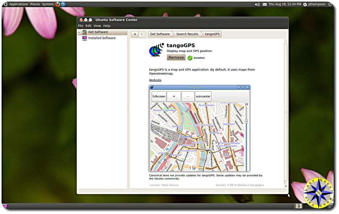
GPS software: there are a number of free mapping software packages available out there. We decided to go with tangoGPS since it was one of the easier ones to work with. It wont do everything some of the other packages will but it does all the stuff on our list. A big selling point for us was the ability to work with open source maps (OSM) as well as Google Maps, Opencyclemap and others. As new map sources become available you can configure tangGPS to use them. Jeff found one source that takes OSM maps and layers them over GIS Topo maps. Simply add a new map type in the tangoGPS configuration tab and point to its URI (uniform resource identifier). In this case it was: “http://mobilemap.petschge.de/topomirror.php?z=%d&x=%d&y=%d”
Each mapping project tends to focus on different aspects when creating their maps such as roads, businesses, trails or what not. With the ability to use multiple maps you can see your location from different perspectives and verify the information across multiple sources.
When you are connected to the Internet, tangoGPS can automatically down load map tiles (fancy term for little picture) as needed. These same cached map tiles are than available to you when you are off line. If you’re not sure of exactly where you will be exploring in a particular area you can zoom out and down load all the tiles of that area. We downloaded all the map tiles for the Olympia Mountains (about a 1,000 square mile area)… it took 22 hours and we have a fast connection! There is are several levels of detail and you can choose to down load some or all of them.
 tangoGPS is one of the applications in the Ubuntu App Manager which means installation is simply clicking on the install button, making it extremely easy to install or remove. Navigation within and Configuration of tangoGPS are straightforward as well.
There is even a “Friends” option which, if you have an Internet connection, will allow you to publish your location and leave a message to a website letting friends know you’re OK.
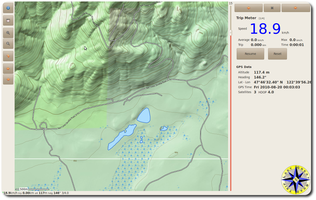
When you install tangoGPS, the App Manager also downloads the GPS demon (Unix speak for program) known appropriately as gpsd. This little demon allows you to hook up and integrate a GPS satellite receiver with tangoGPS. By integrate I mean plug-in, tangoGPS takes it from there. With a GPS satellite receiver (or two) tangoGPS locates you on the maps, allowing you to track your movements, create bread crumb trails (record way-points) and view information such as your longitude, latitude, heading, elevation and speed.
It is at this point we hit the wall with free.
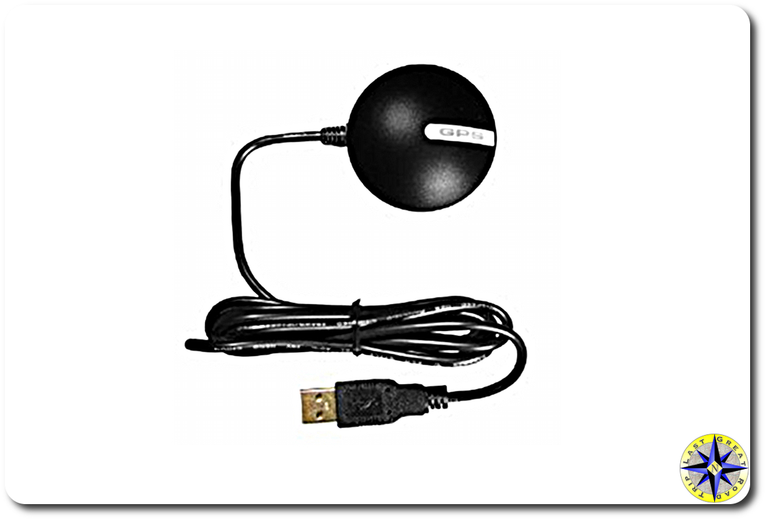 GPS Receiver: Obtaining a GPS receiver required us to crack the piggy bank. If we were going to get the most out of our system this was a must have item. Fortunately for the little piggy a GlobalSat BU-353 Waterproof USB GPS Receiver was only $37.50. Certainly there are more expensive receivers, but this little unit worked great. And with it’s USB connector, integrating it with our laptop couldn’t be simpler.
The GlobalSat receiver came with a little suction cup and has a magnet in its base so you can attach it just about anywhere.
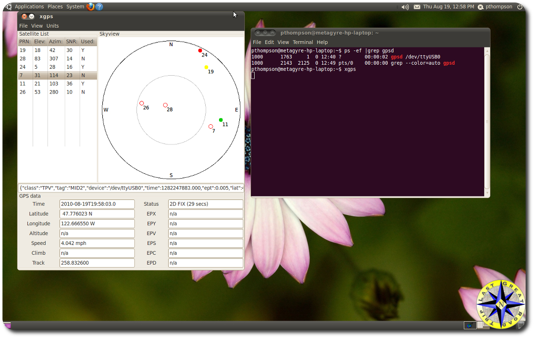 After plugging in the GPS receiver and starting up tangoGPS everything should just work. Last great software lie right. Well it did for us. If you run into any problems with your receiver or want a view of what is going on with it you can peer into the black hole and eaily test it. Plug in the GPS receiver and start the GPS demon with the following command: gpsd /dev/ttyUSB0 Than start up the simple viewer called xgps. You may need to add this program using the Ubuntu app manager if you did not add it when installing the tangoGPS package. To start the viewer type xgps on the command line. xgps will display a window showing the satellites available to the receiver, their signal strength and location. It will also show you the information that gpsd is parsing out.
Getting this all to work sitting on the back deck is one thing, having it work while driving 70 mph down the highway is another. To put our new GPS system through its paces we decided to drag it with us on a recent off-road camping and fishing adventure . We loaded the maps from Seattle, WA to Eugene, OR and the areas surrounding the north fork of the Willamette River. The system worked better than expected. In our test we stuck the lap top in the passenger’s seat with the GPS receiver tossed up on the dash. The system tracked our every movement, keeping our position centered in the screen, clearly showing details that are lost on the smaller GPS units. The GPS and maps lined up exactly and with a single mouse click we could zoom in or out without missing a beat.
There is one small issue to get used to with a system like this. Driving at night, a 17 monitor will illuminate everything around it and more often than not as we passed others on the highway, heads turned as they noticed the glow emanating from the passengers seat. At the rest stops, several folks would wonder over to get a better look at the system, ask about it and inquire where we were heading. But this is a small price to pay for a GPS system that can do so much and cost so little. Now to try it out on a worthy adventure.
I was wondering what to do with that old laptop and wanted a similar system. Thanks for the post.
Great writeup! One question… Does it work with Google Earth? Some friends are flying a map and then downloading it to use similarly to how you are using your maps.
thanks for the info
dale
Dale thanks… Jeff wrote a webapp (http://a.ntivir.us/dev/tango2kml/) that will convert tangoGPS log files into a format that can be used by Google. That way you can share it out with friends.
Nice addition Paul!
To combat the glaring lights at night, try one of those privacy film things, most of them come with little ‘brackets’ that let you take it on/off quick and easy.
Thanks Jeff. Hula Betty kinda likes dancing under the lights… but I’ll probably look into a security screen.
For my laptop gps in my FJ at night, I have purchased a piece of red, transparent plastic sheet from the local hobby store. I simply attach it to my screen, turn the brightness to the desired level and the red plastic dims the light from the netbook, won’t hurt my night vision and to the cool factor is high!
Great recommendation. Thanks for the tip.
Nice write up Paul, I have been wanting to do this same thing with our laptop.
Thanks Rueben give it a go.