Tag Archives: road trip adventure

boy skating burnside skate park

Pre-function… Or Road Trip To The Road Trip

skate trip carThe great thing about road trips is they never really begin or end. And though on the last great road trip team I am the son, in life I play a father for two great kids. Today I drove down to Portland, Or. with my boy. We made the trip to see our friends at Metal Tech who are doing several mods on the Toyota FJ Cruiser. I will tell everyone about that tomorrow. But coming into town a day early gave Boy and I time to kill and for Boy there is no better way to deal with time than by tearing up a skate park.

Those who know skateboarding have heard of the Burnside Skate Park. Famous around the world for the skaters who fought the man and the skaters won. In 1990 skaters cleared away the bottles, cans and trash to put up a few transitions right on the concrete pillars of the Burnside Bridge. Over time skaters added in more transition and bowls until in 1992, the city recognizedskating burnside skate park that under the Burnside Bridge was a city skate park. One of the most unlikely places for a park, it sits beneath the bridge in the industrial area just east of down town with trucks and forklifts moving all about. The skate park looks as sketchy and underground as its surroundings. This is exactly its appeal and since it was built by skateboarders, it reflects what skateboarders like to skate not some municipal engineers idea of skating.

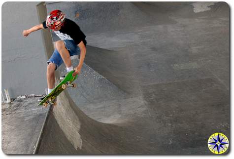
Boy loves to skate Burnside whenever we drop into Portland. The thing we have discovered about the Burnside skate park is that you never know… and you don’t. What does that mean?half pipe burnside skate park

It means sometimes you will run into friends that moved out of the state and made a pilgrimage back just to skate Burnside. Sometimes it will be pouring down rain… this is Portland remember… and Burnside skate park is the only dry park filled with every skateboarder in town. Other times you have the whole park to yourself, the only sound is the constant drown of tires hitting the expansion gaps in the bridge above and you thrash around the transitions.tosh townend burnside skate park

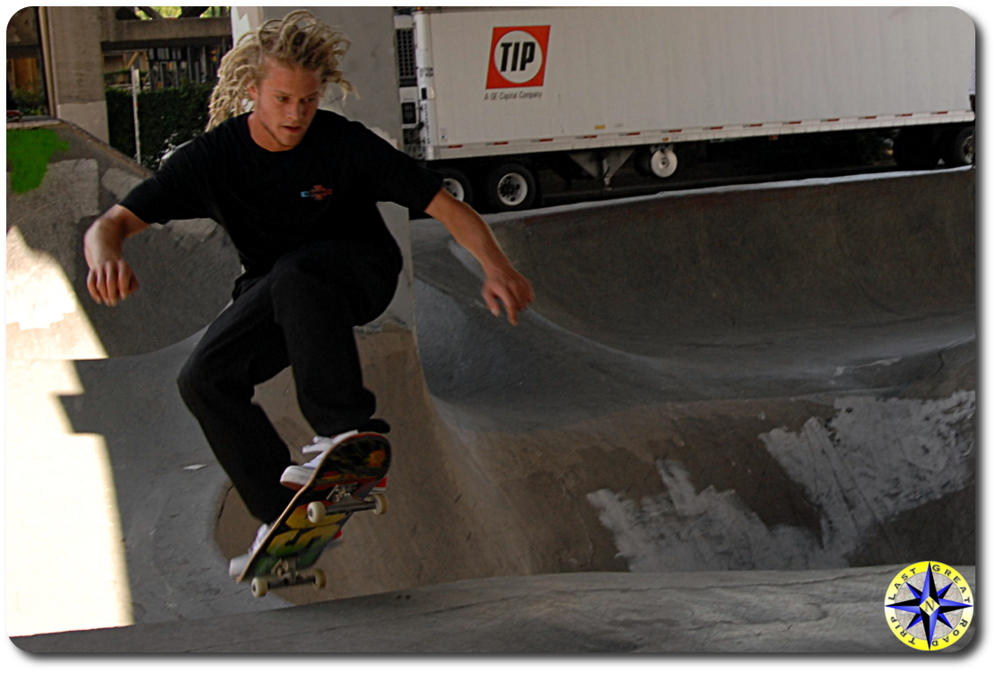
This time, with the rain threatening, Boy made a few warm up runs in an empty park. After a ten minutes of soulful skating and solitude, a van pulled up. This weren’t no ordinary van, it pulled into the lot like… like a prom queen yelling look at me in the middle of the home coming parade. The van was wrapped with graphics front to rear displaying earth, wind and fire, the three elements of life. When the van stopped next to the park’s quasi entrance, out poured a bunch of pro-skateboarders from team Element, including Chad Muska, Levi Brown and Tosh Townend. These were real skateboard pros. The type of pros who skate each day on a dozen new boards, have their pictures in magazines and posters. They have their own camera crew filming them for the next “Lords of Dog Town”, and they make personal appearances at shopping malls and skate-centers hawking decks, trucks, wheels, shoes, shirts, energy drinks and anything else marketing experts feel they can get young teenage boys to buy.tosh townend boy chad muska burnside skate park

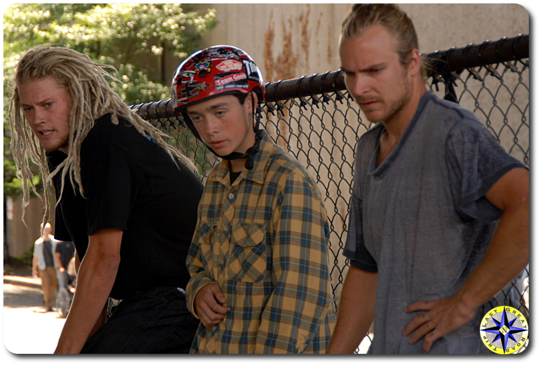
But today the pros of Team Element were at Burnside just to skate. Just to spend time at Burnside as regular guys who love skating with their friends. And today, Boy was one of their friends who they would hang and skate with.levi brown chad muska burnside skate park

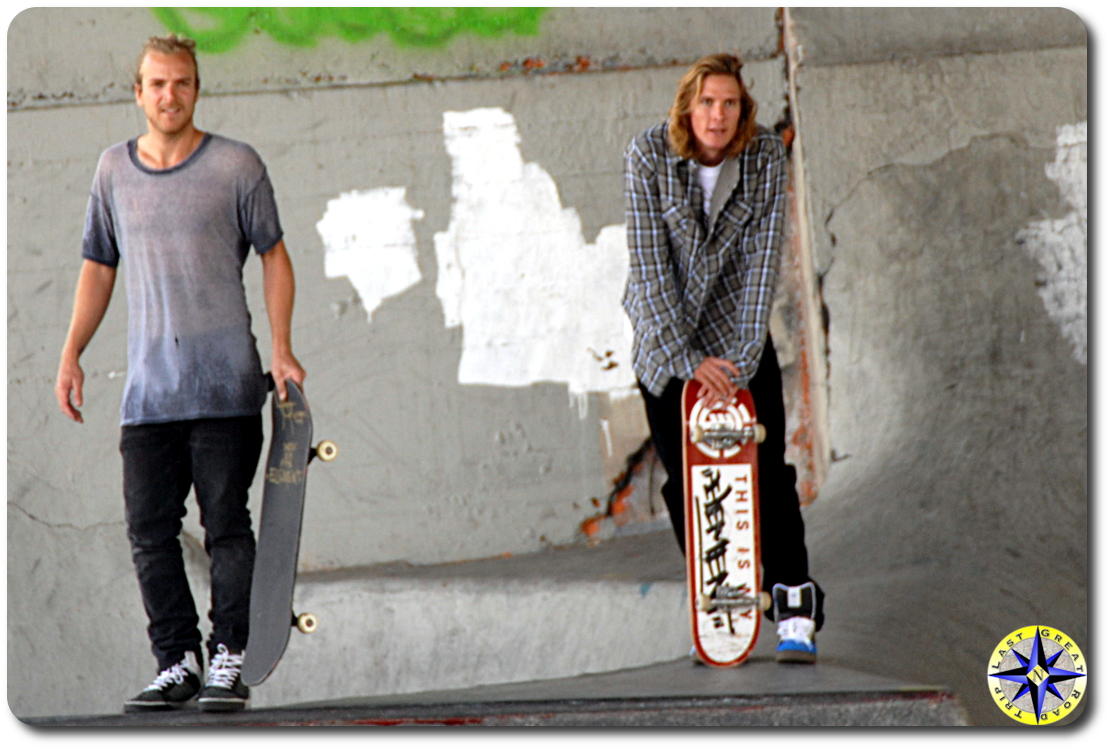
Watching Boy skate is always exciting as he throws himself into it with everything he has. Today was no exception and having
several of his heroes applauding and encouraging him made it that much better when he stuck the landing.

And if you’re ever in Portland, Or. on the east side under the Burnside bridge look for some of the new feature the skateboarder are adding. A continual work in progress, skateboarders are always looking for new challenges in Chad Muska Levi Brown Tosh Townend burnside skate park
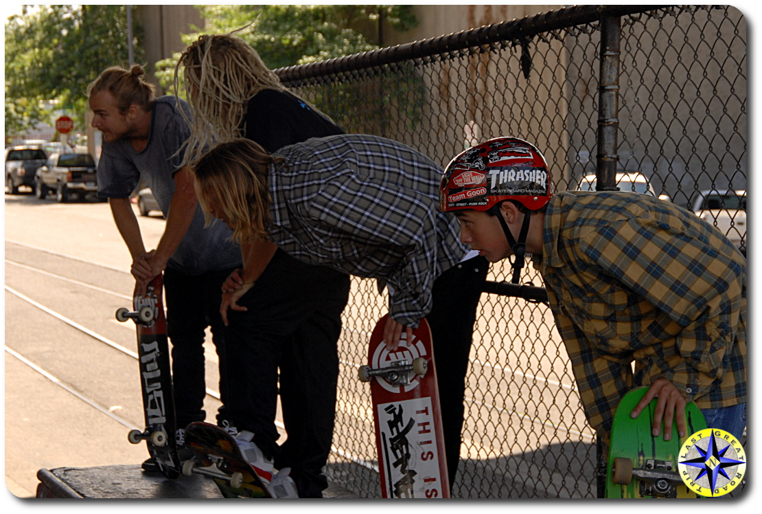
their sport. Whether it is jumping the great wall of China or traveling city to city in the team van, at the end of the day these guys still remember it is fun to skate and hang out with you friends.

Bonus feature: Here is the Element skate session video  (unfortunately Element took it down). Look for cameo appearances by Boy and the rig.

FJ cruiser haul road

“The Haul Road” Is The Road Trip

dalton highway visitor guideFriends and family have asked why Deadhorse, why the Dalton Highway, why not Anchorage? I think the Bureau of Land Management described it best in their The Dalton Highway brochure when they wrote: “Ultimate Road Adventure“. The Dalton Highway is a primitive road that begins 84 miles (134 km) north of Fairbanks and ends 414 miles (662 km) later in Deadhorse, the industrial camp at Prudhoe Bay. It provides a rare opportunity to traverse a remote, unpopulated part of Alaska to the very top of the continent. Traveling this farthest-north road involves real risks and challenges.”

To help decide if you are up to the challenge and assist in preparing for the experience the BLM has put together a great resource. You can down load “Dalton Highway 2008 visitor guide“.

Great snippets you’ll find include:
KNOW BEFORE YOU GO

  • There is no public access to the Arctic Ocean from Deadhorse.
  • There are no medical facilities between Fairbanks and Deadhorse, a distance of 500 miles/800 km
  • Food, gas, and vehicle repair service are extremely limited
  • There are no banks along the highway

After reading through the brochure you get a sense that if you are looking for miles of nothing this is the stretch of road for you. For the last great road trip, this is the exact description we were looking for. We’ll of course pack an extra spare, a can of gas along with a few bags of Cheetos and beef jerky.

When describing road conditions, the BLM states: “The road is narrow, has soft shoulders, high embankments, and steep hills. There are lengthy stretches of gravel surface with sharp rocks, potholes, washboard, and, depending on the weather, clouds of dust or slick mud. Watch out for dangerous curves and loose gravel. You may encounter snow and ice north of Coldfoot any month of the year. Expect and prepare for all conditions.”

Like most things in the far north, the rules of the road have been modified to include a few you might not find in the lower 48:

  • Big trucks have the right of way
  • Stay on the right side of the road
  • If you spot wildlife, pull over to a safe location before stopping

And all this… is why the Haul Road is the last great road trip’s final destination.

Update: here is the Dalton Highway 2013 visitor guide

chicken alaska sign

Mapping Out Our Route To The Arctic Circle

delorme alaska atlas coverThose in the northwest know Metsker Maps of Seattle as one of the greatest places to find directions. Located in Downtown Seattle on 1st Avenue between Pike & Pine, in the Sanitary Market Building of the historic Pike Place Market. They have a huge selection of maps and a ton of other geography related products.

The guys at Metsker Maps helped the team sort through and locate copies of the Alaska Atlas & Gazetteer as well as British Columbia Road & Recreational Atlas. Both of these atlases are very detailed, filled with the information we need to not only map out a direct route but also ensure we can find those “off the beaten path” destinations. One atlas remains to be found that covers Canada’s Yukon Territory. You can see the route we’re looking at on the Travel Maps pages. While the map images are high level highway maps, you can see the scale of this adventure.

Since we have the FJ Cruiser for this trip, we plan to make good use of the atlases to chart out dirt trails that can be explored.

Many folks have asked if we’re going to get a GPS. The answer so far has been no. We still feel that a compass, accurate detailed maps and the knowledge of how to use both can be more useful than most GPS available at a reasonable price. Also, for me at least, turning the pages of a map is a prelude to driving the trails and looking just beyond the next bend in the road.

4 siberian husky sled dogs in harness

The New Milepost Is Here…

2007 MilepostThe new Milepost is here, the new Milepost is here…  I am somebody!

For those of you old enough to remember Steve Martin’s “The Jerk” you get the reference.

My mother believes a road trip is the drive to the mall, the four seasons is roughing it and a hike involves riding the escalator at Nordstrom. However, when my dad and I started talking about this adventure, mom was the first to go on-line and start ordering books and maps for us. Today “The Milepost” 2007 edition arrived. It seems to have information on everything for our adventure through BC, Alaska and the Yukon. With this resource we will be able to make last minute itinerary changes allowing us to avoid planning all the spontaneity out of this trip.

We will still need to find some off-road trails without mile markers to poke around on as we work our way to the Arctic Circle and back.

alaska marine highway prince rupert terminal

No Turning Back Now

The Alaska Marine Hwy ferry tickets arrived. For the same price as a luxury seven day cruse you get to bring your rig with you on a six-stop 2 1/2 day trip along the Inside Passage from Bellingham Washington to Haines Alaska. The accommodation may be tight and you’re on your own for meals, but the company promises to be interesting and the scenery spectacular. We will see how it turns out… there is no turning back now with tickets in hand!

And just when you think it’s smooth sailing…  Karma kicks you in the teeth and throws a wrench into all your best laid plans.

foggy dempster highway

One Truck, two generations, 14 days, 5000 miles

Follow this father and son road trip adventure as they take this once in a lifetime journey.  Our travelers will keep everyone up to date through their blog with stories and pictures.

The Arctic Circle remains one of the last great wildernesses you can reach by “road”. On August 24, 2007 a father son team is setting off, in their Toyota FJ Cruiser, from Poulsbo, Washington and driving to the Arctic Circle. The two road warriors will attempt to travel over 5,200 miles in 14 days traveling on the Alaska Marine Hwy, Alaskan Canadian Hwy (ALCAN) and highways that can best be described as gravel paths.

Excitement is building on the web and in the press about this adventure. This site will record their day by day adventures through stories, pictures and video. Check the blog for up to date adventure highlights.

The first leg of the journey is through the scenic waterways of Southeastern Alaska’s Inside Passage. The ferries of the Alaska Marine Highway will carry the pair of road warriors and their Toyota FJ Cruiser from Bellingham, WA. to the southeastern ports of Ketchikan, Wrangell, Petersburg, Sitka, Juneau (Alaska’s capital), off loading in Haines AK.

From Haines the travelers will drive north joining up with the Alaskan Canada Highway at Haines Junction. The early legs of the trip are a hard push to reach Fairbanks Alaska which the pair will use as its jumping off point to the Arctic Circle. The 414-mile Dalton Highway, still called the ‘Haul Road’ connects the oil fields of Prudhoe Bay on the North Slope with mainstream Alaska and is one of Alaska’s most remote and challenging roads. Mostly gravel, motorists need to watch for ruts, rocks, dust in dry weather, potholes in wet weather and trucks and road maintenance equipment at all times.

The first stop on Haul Road is Coldfoot one of the few Alaska communities north of the Arctic Circle accessible by road. Described as a bit of a one-horse town it will be the first overnight stop on the Dalton Highway.

The end of the trail is Deadhorse 498 miles north of Fairbanks near the Arctic Ocean and is the end of the Haul Road.

After the dust covered adventurers return to Fairbanks, a leisurely journey back down the ALCAN Hwy will carry the pair south through two countries, two provinces and two states. While the itinerary sets some goals, the mark of a great road trip is the freedom to take a side road just because it looks interesting.

Follow the father son adventures as they take this once in a lifetime journey. The travelers will keep everyone up to date through their blog with stories and pictures. Just don’t be surprised if a few days elapse between updates as Internet access may not be as available clean air, wide open spaces and magnificent scenery.

See itinerary and maps of the last great road trip. See the entire arctic circle road trip adventure.

denali national park alaska

Adventure FACTS

plowing snowy alaska roadInteresting facts about a region of the country that is rough and unforgiving. This is at least what the travel books say. We will attempt to identify facts a little more personal to us as we make this adventure our own.

Alaska facts

  1. Russian whalers and fur traders on Kodiak Island established the first settlement in Alaska in 1784.
  2. In 1867 United States Secretary of State William H. Seward offered Russia $7,200,000, or two cents per acre, for Alaska.
  3. Alaska officially became the 49th state on January 3, 1959.
  4. The state of Rhode Island could fit into Alaska 425 times.
  5. Prudhoe Bay, on the northern Alaskan coast, is North America’s largest oil field.
  6. The Trans-Alaska Pipeline moves up to 88,000 barrels of oil per hour on its 800 mile journey to Valdez.
  7. The fishing and seafood industry is the state’s largest private industry employer.
  8. Dog mushing is the official state sport. The Alaska Legislature adopted it in 1972.
  9. The state motto is North to the Future.
  10. The jade is the official state gemstone.
  11. Gold is the official state mineral. It was named the state mineral in 1968.
  12. Alaska’s Constitution was adopted in 1956 and became effective in 1959 making it the 49th state.
  13. Nearly one-third of Alaska lies within the Arctic Circle.
  14. The state boasts the lowest population density in the nation.
  15. Alaska is the United State’s largest state and is over twice the size of Texas. Measuring from north to south the state is approximately 1,400 miles long and measuring from east to west it is 2,700 miles wide.
  16. At 20,320 feet above sea level, Mt. McKinley, located in Alaska’s interior, is the highest point in North America.
  17. Juneau is the only capital city in the United States accessible only by boat or plane.
  18. The state’s largest city is Anchorage; the second largest is Fairbanks.
  19. The Alaska Range is the largest mountain chain in the state. It covers from the Alaska Peninsula to the Yukon Territory.
alaska state tourist map

Travel Maps

Our adventure can be broken into three big chunks…  After all this is Alaska so they have to be Big chunks as shown on this Alaska state tourist map.

Alaska Marine Highway Alaska’s Inside Passage treats you to spectacular natural beauty, an unmatched variety of wildlife, plus a rich mixture of Native, Early Russian and Gold Rush history. For those of us coming from the “lower 48”, the trip north to Alaska on the marine highway begins at Bellingham, WA. At the northern end of the route, Haines, AK. links us to the Alaskan Highway.

Alaska is a vast land, well deserving of the title, “The Last Frontier.” The majesty stretches from the lush forests of the Inside Passage to the open tundra of the North Slope, from the borders of British Columbia to the windswept Aleutian Islands. We will start by exploring these far flung communities by driving Alaska’s “other” highway.

Haul Road The 424-mile Dalton Highway begins at Mile 73 on the Elliott Highway, 84 miles north of Fairbanks. The Dalton Highway is unique in its scenic beauty, wildlife and recreational opportunities, but it is also one of Alaska’s most remote and challenging roads. Not for the timid or the unprepared. The Dalton Highway is one of the last great adventure roads in the United States. If you have the right vehicle and plan ahead, it can be one of the most satisfying drives of a lifetime. Mostly gravel, two lanes, hilly in places, bumpy in many, lonely with few service facilities along the way. Motorists need to watch for ruts, rocks, dust in dry weather, potholes in wet weather and trucks and road maintenance equipment at all times. For a more in depth look at Haul Road see “The Haul Road” is the road trip.

ALCAN Construction of this highway officially began on March 8, 1942 and ended eight months and 12 days later on October 25, 1942. The bombing of Pearl Harbor in December of 1941 deemed the construction of the highway was a military necessity. Alaska was considered vulnerable to a Japanese invasion.

The Alcan Highway stretches in a northwesterly direction from mile 0 at Dawson Creek, BC through Yukon Territory to mile 1520 at Fairbanks, AK. The Alcan highway does not compare with highways in the lower 48, it is no longer a wilderness road, but rather a road in the wilderness. The highway is open and maintained year-round.

The highway is asphalt-surfaced, but the condition ranges from poor to excellent. There are many chuckholes, gravel breaks, poor shoulders, and bumps.

color map of alaska regions

Itinerary

For me really good road trips have always had the freedom to be spontaneous. You shouldn’t have to worry about where you are going that day, how you are getting there or where you are staying when you get there. If you come to a side road with the worlds largest ball of twine at the end, run down and see it because you never know when you will have that chance again.

I think of the itinerary below as our guiding principles, with a few hard facts. We leave August 24. We are taking the Alaska Marine Highway ferry up to Haines and the ferry will leave without us if we don’t show up on time. We need to be back around September 7th, and of course we’re going to the Arctic Circle, and than some.

A few folks are now suggesting to us that Inuvik is a more interesting choice than Deadhorse as a northern destination. Leave comments and let us know where you would go. We have the freedom on this trip to run a social experiment where the people of the blog guide its outcome and literally set the direction.

DayLeaveMilesArrive
1 & 2Poulsbo, WA. USA1032Haines, AK. USA
3Haines, AK. USA438TOK, AK. USA
4TOK, AK. USA456Coldfoot, AK. USA
5Coldfoot, AK. USA242Deadhorse, AK. USA
6Deadhorse, AK. USA242Coldfoot, AK. USA
7Coldfoot, AK. USA255Fairbanks, AK. USA
8Fairbanks, AK. USA416Burwash Station, YT. Canada
9Burwash Station, YT. Canada283Teslin, YT. Canada
10Teslin, YT. Canada331Muncho Lake, BC. Canada
11Muncho Lake, BC. Canada431Dawson Creek, BC. Canada
12Dawson Creek, BC. Canada399Williams Lake, BC. Canada
13Williams Lake, BC. Canada417Poulsbo, WA. USA

Of course plans are meant to change and who knows where else we’ll explore on this adventure… all we know is that it will change for one reason or another.